Day 12 / Power / New York State, USA
New York's long extension lead
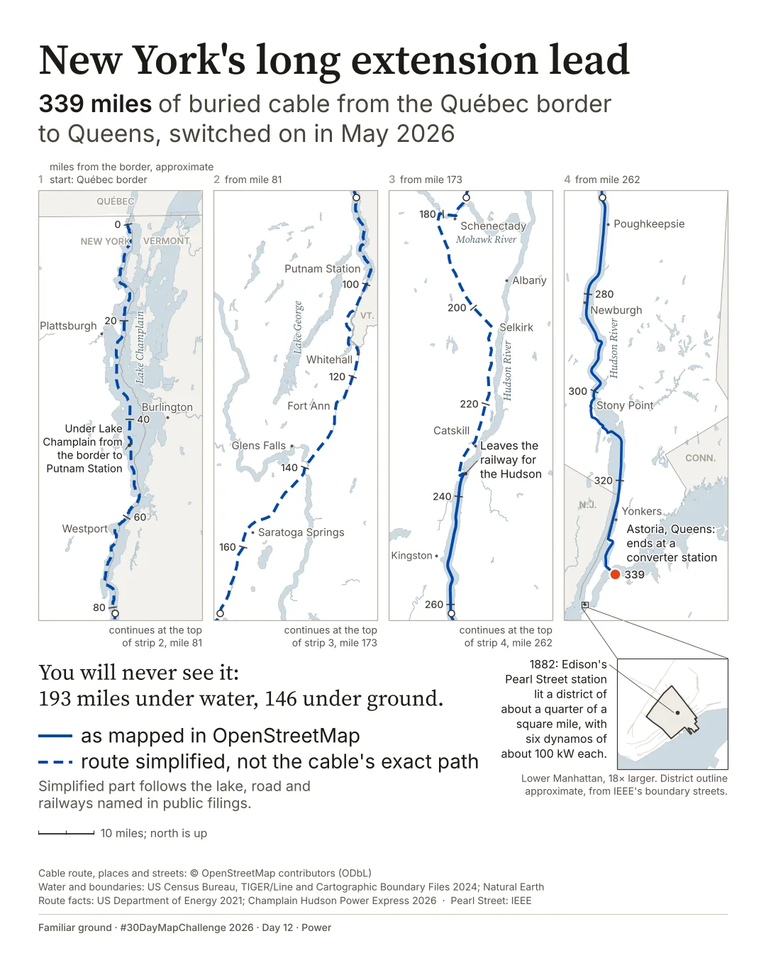
193 of its 339 miles lie under water, in Lake Champlain and the Hudson and Harlem rivers. The other 146 are under ground.
Where does New York's newest power line run, when none of it can be seen?
Posted on LinkedIn on .
 Enlarge
Credits: Route and streets: © OpenStreetMap contributors (ODbL) · Water and boundaries: U.S. Census Bureau · Natural Earth. Full sources
339 miles
of buried cable, from the Québec border to Astoria, Queens
193 miles
under water. The other 146 are under ground, mostly along roads and railways
About a quarter of a square mile
lit by Edison's Pearl Street station in 1882, drawn at the same scale
The thinking
What I tried and why
I wanted to draw something nobody can see. The line is long and thin, so I cut it into four strips read side by side, top to bottom, following the power south. It is a strip map, and it lets one 339-mile line fill a tall page at one scale.
Only the southern 103 miles are mapped in OpenStreetMap. North of that I drew a simplified line along the lake, road and railways named in public filings. That part is dashed, so the map never claims to know the cable's exact path.
At the foot of the last strip, at the same scale, sits the district Edison's Pearl Street station lit in 1882. It is a speck.
Method
How it was made
The southern 103.2 miles, Cementon to Astoria, are the cable as mapped in OpenStreetMap. The 227.7 miles from the border to Cementon were simplified from the route described in public filings: a schematic line down Lake Champlain, then NY Route 22 and the CP and CSX railways from OpenStreetMap, joined by five short straight connectors. Water, land and state lines come from U.S. Census Bureau files, and Québec from Natural Earth. The 339, 193 and 146 mile figures are the operator's published totals, not measured from the drawing, which comes to 331.0 miles. Mile marks count back from 339 at Astoria and are approximate. The four strips cover equal north-south distances and are shifted, never rotated, so north is up and the scale is the same throughout.
Limits
What this cannot tell you
The dashed northern part is not the cable's exact path. Mile marks are approximate, and up to 11 miles off the 2021 federal route table in places, so no mileage is given for the lake. Rivers are drawn wider than life, up to about 2.3 km where the Hudson is about 0.5 km, so the line can be seen in the water. The map shows where the line runs, not how much power it carries. A cable fault kept it off for most of July. New York State says it can meet up to 20% of the city's electricity needs, which is a claim of capability, not a measured flow. The outline of Edison's district is approximate.
Next
What I’d do next
I would make the strip numbers larger, since the reading order leans on them, and draw the split between water and ground on the line itself, not only in words.
Read my learning logData and credits
Sources
Data were filtered, joined and re-symbolised. The northern route was simplified from open base data and the wording of public filings, not traced from any route drawing.
- Cable route, places and streets · OpenStreetMap
- Cable route, places and streets: © OpenStreetMap contributors, ODbL.Open Database Licence (ODbL)
- Water · U.S. Census Bureau
- Water: U.S. Census Bureau, TIGER/Line Shapefiles 2024.Public domain
- Land and state lines · U.S. Census Bureau
- Land and state lines: U.S. Census Bureau, Cartographic Boundary Files 2024.Public domain
- Québec land and lake · Natural Earth
- Made with Natural Earth.Public domain
- Route facts · US Department of Energy and the operator
- Route facts: US Department of Energy, Supplement Analysis DOE/EIS-0447-SA-1 (2021); Champlain Hudson Power Express (16 June 2026).Facts cited
- Pearl Street · IEEE
- Pearl Street: IEEE Milestone, "Pearl Street Station, 1882".Facts cited
Map design and text © 2026 Spatial Nexus. All rights reserved. Source data retain the licences above. Every source across the series is on the credits page.