Day 06 / Vintage / Midlothian
Fewer than half of Midlothian's woods are on recorded old woodland sites
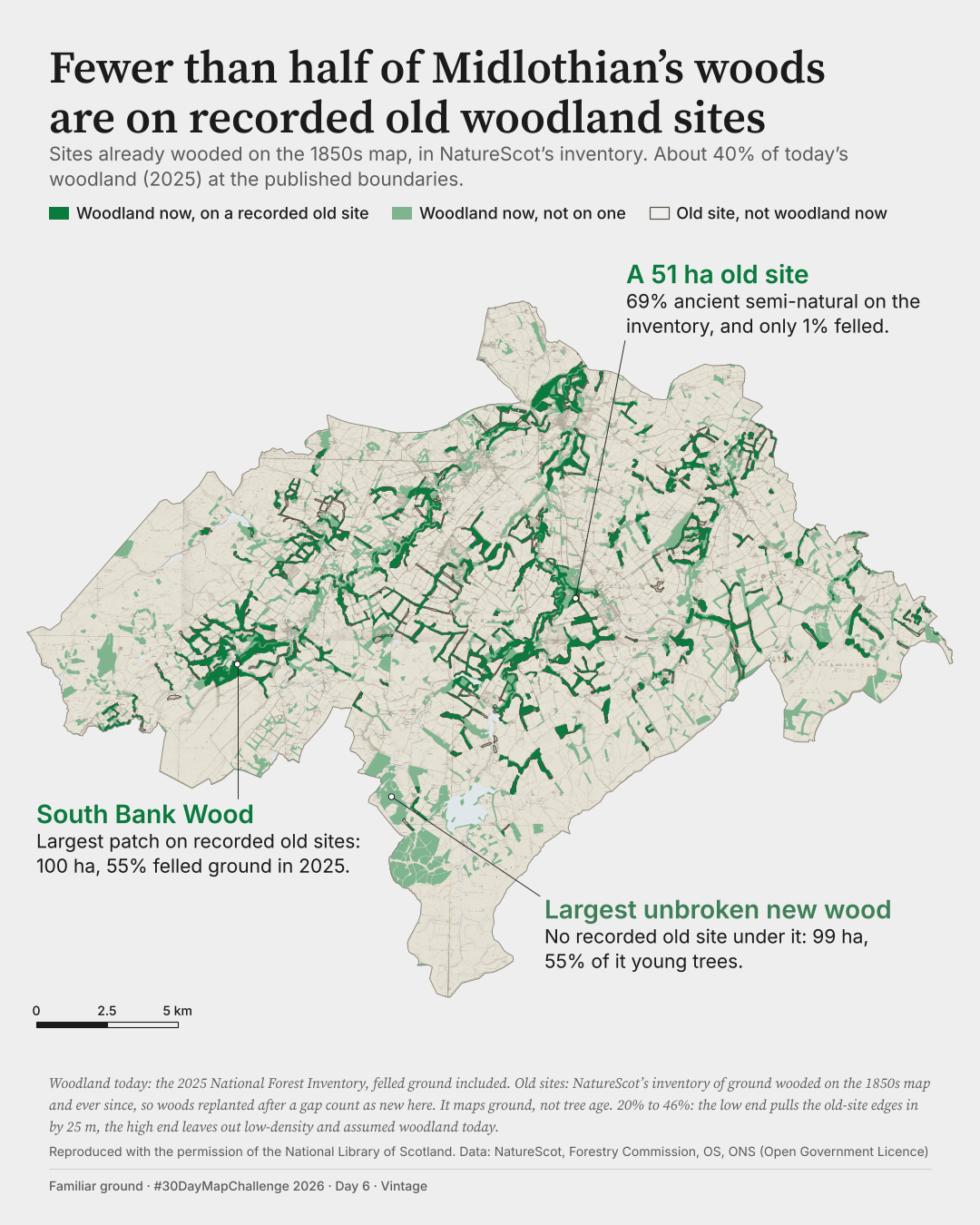
About 40% of today's woodland stands on sites recorded as wooded on the 1850s map.
How much of Midlothian's woodland today stands where the first-edition Ordnance Survey six-inch map of the 1850s shows woodland?
 Enlarge
Credits: National Library of Scotland; NatureScot, Forestry Commission, ONS, Ordnance Survey (OGL v3.0). Full sources
About 40%
of today's woodland lies on recorded old woodland sites, at the published boundaries
20% to 46%
across the edge and woodland definitions I tested; every case is under half
100 ha
South Bank Wood, the largest patch on recorded old sites; 55% is felled ground in 2025
The thinking
What I tried and why
I flattened the old sheets so the ink reads as one quiet sepia over one paper tone, then laid today's woodland over it in two greens: deep for woodland on recorded old sites, lighter for woodland with no old site recorded under it.
I name a patch only when inventory records sharing one name cover at least half of it. South Bank Wood passes, at 52%. Another large patch had a name that covered only 8% of it, so I took the name off and call it a 51 ha old site.
The headline refers to the inventory because that is what was measured. The inventory records sites, not the age of trees, and woods replanted after a gap count as new here.
Method
How it was made
I overlaid today's woodland from the National Forest Inventory Scotland 2025 with NatureScot's Ancient Woodland Inventory, using the codes for sites already wooded on the 1850s map, and measured the share in 12 cases: four woodland definitions by three edge treatments. The low end, 20%, comes from pulling the inventory edges in by 25 m. The high end, 46%, comes from leaving out assumed woodland and low-density woodland.
Limits
What this cannot tell you
This is not a measure of woodland loss. The inventory keeps sites that stayed wooded, so woods replanted after a gap count as new. Felled ground and young trees count as woodland in the 2025 inventory, so green on this map does not always mean standing trees. The georeferencing of the old sheet and inventory polygons carries no accuracy guarantee, and a faint sheet seam remains in the south-west.
Next
What I’d do next
I would decide whether the large block south of the 99 ha patch, split into about two dozen compartments by narrow gaps, should be measured as one wood, and test the map on a real phone.
Read my learning logData and credits
Sources
The data were filtered, clipped to Midlothian and re-symbolised by me.
- Historic map · first-edition OS six-inch, Scotland
- Map reproduced with the permission of the National Library of Scotland: https://maps.nls.ukCC BY, per the National Library of Scotland page wording
- Ancient Woodland Inventory
- © Scottish Natural Heritage Contains Ordnance Survey data © Crown copyright and database right 2026.Open Government Licence v3.0
- National Forest Inventory Scotland 2025
- © Forestry Commission copyright. Contains Ordnance Survey data © Crown copyright and database right 2026.Open Government Licence v3.0
- Council boundary
- Source: Office for National Statistics licensed under the Open Government Licence v.3.0 Contains OS data © Crown copyright and database right 2025.Open Government Licence v3.0
- Water
- Contains Ordnance Survey data © Crown copyright and database right 2026.Open Government Licence v3.0
The historic map comes through the National Library of Scotland's tile service. The tile-service reuse terms still need confirmation.
My map design and text: Creative Commons Attribution 4.0 (CC BY 4.0). Source data retain the licences above. Every source across the series is on the credits page.